Southern Pacific Lines
Coast Line Division
“The Route of the Octopus”
Southern Pacific Lines
Coast Line Division
“The Route of the Octopus”
S.P. Tunnels
Tunnels Construction
Most SP tunnels started off with redwood timber lining. Original tunnel heights were 16’ wide, 18’ max. height, curved with heavy wood timbers. Later the Cuesta tunnels were improved from 1940 to 1954 and increased in width to 18’ and 24 1/2’ high.
Between 1954 to 1959 concrete lining was installed (*see CLP-85 for cross section drawing). Usually, concrete tunnel portals meant the interior was also lined with concrete. In later years some tunnels were daylighted because of earthquakes.
References
Drawings
Coast Line Pictorial, pg. 85 for cross section drawing
Tunnel Numbers Signs
Some tunnel signs were attached to the right side of the tunnel itself. Other tunnel signs were attached to telltales. Tunnel numbers on wooden signs were specified in common standard plan C.S. 9, adopted October 1904. At that time, the signs measured 10" high and 16" wide. By 1921, this plan had been changed so that the length of the tunnel was included, with new sign dimensions of 15" high and 16" wide. Another change called for the signs being made of enameled metal.
John Sweetser
An interesting aspect of the Tehachapi tunnels is that portals for tunnels 3 and 5 had raised numbers (not painted) in the vicinity of the upper right of the portal openings at locations tangent to to the vertical wall of the portals and tangent to the top of the arch of the portals. The raised numbers were around 8 inches high. It’s presumed that other Tehachapi tunnels had similar raised numbers at the time.
The tunnels on the Coast Line were re-numbered after the mid 1920s when tunnel 5 1/2 was dug north of King City.
Tunnel number signs were removed, a case of them being appropriated over time by thieving railfans.
John Sweetser
References
Tunnel Lining - Wood - Santa Cruz, Ca. Model Railroader Sep. 1977
A 1944 photo showing a number sign for Tunnel 9 can be found on the bottom of pg. 141 of Signor's "Tehachapi" (the sign is on the portal to the right and slightly above the caboose marker lamp. Look closely). This photo was taken during the period when telltales were absent in the Tehachapis, which maybe was from the 1930s to the late 1940s.
Drawings
Plans at the Calif. State RR Musuem Library for tunnel number signs:
Southern Pacific. CS 9 Oct. 1904 / Jan. 11, 1927. Common standard: Roadway signs, tunnel and section tool house numbers and curve stakes. Black line on white paper. Filing location:Box 126 ID 24555
Southern Pacific. CS 1316 [Former number: CS 9] Oct. 1904 / Jan. 15, 1932. Common standard: roadway signs, tunnel numbers and curve stakes. Black line on white paper. Filing location:Box 128 ID 25303
Southern Pacific. CS 1316 [Former number: CS 9] Oct. 1904 / Jan. 7, 1955. Common standard: roadway signs, tunnel numbers. Black line on white paper. Filing location:Box 128 ID 25304
Southern Pacific. CS 1316 [Former number: CS 9] Oct. 1904 / Jan. 7, 1955. Common standard: roadway signs, tunnel numbers. Black line on white paper. ID 55149
Tunnel Length
Tunnel Location Length
6 Cuesta 3610’
7 Summit 1410’
8 Thyle
9 Thyle
10 Chorro
11 Chorro
12 Sudden 811’
13 Drake
26 Hasson 7369’
27 Santa Susanna Pass 994’
28 Chatsworth 599’
Tunnel 1 MP
Located at Mission Bay, west of Bay Shore.
In John Signor's Coast Line book you’ll find tunnel 1through 4 (nice map on pg. 32).
Tunnel 2 MP
Located at Army St./23rd St. and collapsed in 1906 S.F. earthquake.
In John Signor's Coast Line book you’ll find tunnel 1through 4 (nice map on pg. 32).
Tunnel 3 MP
Located at Mission Bay.
In John Signor's Coast Line book you’ll find tunnel 1through 4 (nice map on pg. 32).
Tunnel 4 MP
Located at Bay Shore.
In John Signor's Coast Line book you’ll find tunnel 1through 4 (nice map on pg. 32).
Tunnel 5 MP
Tunnel 5 was on the main line between Bayshore and SSF (between Brisbane and South San Francisco) north (rr west) of San Jose. It collapsed in the 1906 S.F. earthquake.
Bruce Morden
It was bypassed in 1956 with the opening of the Bayshore Freeway (US101) Candlestick Cutoff. The south (East) portal was daylighted in the construction, but the rest is still there, although sealed and used for storage of paper records. Heading compass-south from Bayshore, the (railroad) west portal hides off behind the end of the last commercial buildings before the curve around past Sierra Point.
Tunnel 5 1/2 (Metz Tunnel) MP 155.54
Built in 1923.
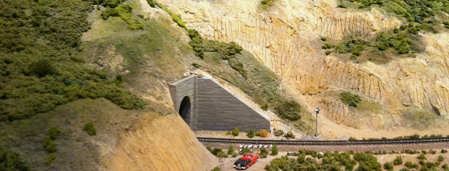
Tunnel 6 (A Cuesta Tunnel) MP 239.63
Tunnel #6 has ribbed concrete walls on the Cuesta. It is 3610’ long.
Water cars were stationed at Cuesta for tunnel fires.
The tunnel caught fire in ‘87, led to end of through freight traffic on Coast Route until 1990, located at Cuesta Summit.
Tunnel 7 (Thyle Tunnel) MP 240.24
Tunnel #7's walls resemble the walls in Disney's Matterhorn toboggan ride. This is because in 1987 its wooden beams caught fire and the coast route was closed for 6 weeks. It was reopened through the efforts of 2 crews working 12 hours each 7 days a week making the repairs. It’s elevation is at 1399’.
Tunnel 8 (A Summit Tunnel) MP 240.66
On the approach to the western portal of Tunnel #8, the searchlight signals guarding it stand facing outwards since they are no
longer valid as they are being replaced with the triangular style of signal.
Tunnel 9 (A Summit Tunnel) MP 240.91
Tunnel 9 (8?) burned around the 1910 date and collapsed IIRC during reconstruction, then was daylighted. Thru service was maintained by walking around the mountainside, from "Hurryup" to "Owlville".
Tunnel 10 (A Summit Tunnel) MP 241.72
This tunnel is on Cuesta, west of Serrano siding. The problem with Tunnel 10 is that the one that collapsed February 24, 1910 was completely removed. The second Tunnel 10 was taken out of service in the 1960's. It is hard to keep the two distinct tunnels separate without knowing the date. I recently was made aware of some information at the California State Railroad Museum Library that talks about Tunnel 11 which I believe is the current Tunnel 10 which is itself bypassed by the current route. The search is still on but I am convinced that Tunnel 10 was once Tunnel 11 and 11 was 12, etc.
Bruce Morden
1910
An article states that the tunnel 10 "collapsed" or "caved in" in 1910, was set on fire and tracks rerouted. The photos shows excavation work being done in the area. The remnants looked to be "boarded up" for a lack of a better description. It was closed due to the unstable ground in the area and left in place as a retaining wall of sorts.
Mike Madonna
Regarding the 1910 picture, from the San Francisco Call of February 25, 1910:
"Santa Barbara, Feb 24. Trains on the Southern Pacific coast line were held here early today [after] a portion of tunnel No.10, near Santa Margarita on the Cuesta grade had caved in at midnight... Forty six feet of the bore is said to have collapsed... [and the cave-in] followed the removal of the timbering in the tunnel preparatory to substituting concrete...
"...the Coast Line Limited will be rerouted over the valley line and local traffic will be cared for as far north as San Luis Obispo."
The immediate fate of *that* tunnel 10 (could there have been more than one over time?) is reported very differently in two sources:
The Los Angeles Times of March 11, 1910 reported that "the Coast line will be opened for traffic some time today and... trains may take up their regular schedule.... the tunnel had to be recleared and concreted... and cost approximately $500,000, for the entire tunnel was concreted and the whole forty-five feet of cave has been removed." It then goes on about the great effort Espe took to reroute freight "with little loss of time."
1958
It's listed in the 1958 Spec Instr, not in the 1964. It was still in use in the early 60's, bypassed about 1962. The work to bypass was done within a few months after that, but certainly prior to 1966. Tunnel 10 remains on the tip of the ridge above Hwy 101.
1962
To the best of my recollection, the tunnel was boarded up. I do remember there was a sign on both ends of the tunnel saying "DANGER UNSTABLE GROUND". They bypassed about 1962. The work to bypass was done within a few months after that, but certainly prior to 1966. Tunnel 10 remains on the tip of the ridge above Hwy 101. They put some earth fill and relaid the track to go around the outside of the tunnel.
Gordon Searle
1972
The 1970s track chart shows a 12-degree curve there, and It’s probable the curve thru the tunnel was a 10-deg. Tunnel 10 is/was a couple miles below the summit. Right where the RR makes a 150-degree turn around the end of the ridge.
In July 1972, a train derailed at Tunnel 10, where another train had derailed maybe three days before. For the next several years there were instructions in the timetable, something like trains with 24 powered axles on head end must reduce to Run 6 when any portion of the train was between MP241-242, and head end must not pull more than 4250 tons, and if helper goes down causing head end to pull more than 4250 tons assistance must be obtained.
2000
There's a photo of the boarded up east portal on Google Earth. This unstable ground still shows to this day with evidences of the roadbed sliding out between Chorro and West end of Serrano.
Denny Dollahon
I have posted some scans of a 1916 timetable, and two Special Instructions from 1949 and 1961. All three show the same numbering of the existing tunnels on Cuesta. I have also included an Aston photo of the collapsed Tunnel 10. You can see the top of Cuesta in the distance so this is not the sealed tunnel location. I have included a map showing the tunnel locations. All this is in the Cuesta Tunnels folder at: https://groups.yahoo.com/neo/groups/Espee/files/Cuesta%20Tunnels
Bruce Morden
Tunnel 11 (Chorro Tunnel) MP 245.82
Located near Serrano.
*Southern Pacific. *Coast Division 10349 B Feb. 15, 1909
Nova-Thyle map showing sink and slide near old tunnel No. 11, Coast
Division. Scale 1:100. 14 x 16 Ink on linen; white line on blue paper. ID 20397
Tunnel 12 (Sudden / Ellwood Tunnel?) MP
Tunnel 12 was in the deep cut at the east end of Sudden siding. Built in 1900, it was 811’ long. The east tunnel portal was concrete, as evidenced by photos on page 32 of the January 1956 SP Bulletin, page. 226 of "Southern Pacific's Coast Line" and page 188 of "Southern Pacific's Coast Line Pictorial". The latter photo shows the tunnel being daylighted between 1955 and 1958. Usually, concrete tunnel portals meant the interior was also lined with concrete. The excavation work above and to the right of the portal in the photo on pg. 188 of "Southern Pacific's Coast Line Pictorial" tells me the tunnel went through soft material, not rock.
John Sweetser
Tunnel 12 at Sudden was demolished 1956.
Tunnel 13 (Drake Tunnel) MP
Built in 1900. Tunnel 13 was in the deep cut at the west end of Sacate siding (which itself slid into the ocean around the winter of 1977 - 1978). Tunnels 13 were daylighted 2-20-1943.
Denny Dollahon
Tunnel 14 MP
Tunnel 14 was on the original Coast Line between San Fernando and Saugus where the Coast Line split from the Valley Line. This was the original alignment before the Montalvo cutoff was built between Montalvo and Burbank Junction. Tunnel 14 is still on the ex-Valley Line (now Metrolink).
Denny Dollahon
Tunnel 20’s MP
The tunnels on the Montalvo cutoff are numbered in the 20s with the longest being tunnel 26.
Denny Dollahon
Tunnel 25 MP
It was on the San Joaquin Division at the time and ran through San Fernando Pass.
David Coscia
Tunnel 26 (Hasson Tunnel, A Santa Susanna Tunnel) MP
One of the 3 Montalvo cut-off tunnels in Chatsworth are Tunnels 26, 27, and 28. They were on the San Joaquin Division at the time and were thus numbered in order after the previous tunnel on the division.
David Coscia
The summit is located inside tunnel 26. It is 7,369 feet long.
A metal sign on the right side reads; #26 and below it "7369 FT".
See: http://www.minervaclassics.com/railroad/railroad.htm#espee
Tunnel 27 (A Santa Susanna Tunnel) MP
One of the 3 Montalvo cut-off tunnels in Chatsworth are Tunnels 26, 27, and 28. They were on the San Joaquin Division at the time and were thus numbered in order after the previous tunnel on the division.
David Coscia
It is 924 feet long.
Tunnel 28 (Chatsworth Tunnel, A Santa Susanna Tunnel) MP
One of the 3 Montalvo cut-off tunnels in Chatsworth are Tunnels 26, 27, and 28. They were on the San Joaquin Division at the time and were thus numbered in order after the previous tunnel on the division.
David Coscia
It is 537 feet long.
Tunnel 29 (Searles Tunnel) MP